Syngenta today announced it has acquired FarmShots, Inc., a North Carolina-based innovator of high-resolution satellite imagery that detects plant health by analyzing absorbed light from field images.
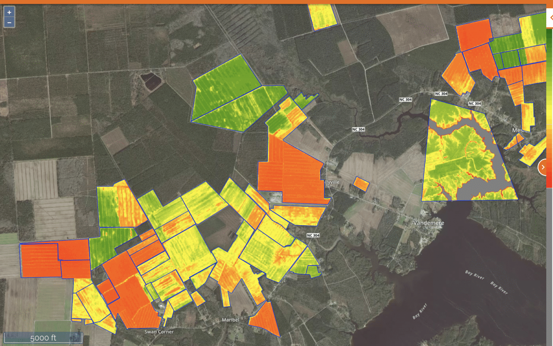
This service was developed to help farmers, agronomists and retailers quickly and accurately spot field issues caused by planter skips, emergence, insect feeding, poor plant nutrition, crop diseases, weeds, other pests and environmental damage. With this capability, FarmShots enables growers and their trusted advisers to reduce field scouting by as much as 90 percent and helps them focus on areas of need.
“FarmShots is a new and unique service that helps us deliver on our commitment to further develop farm management and crop decision-making tools,” says Dan Burdett, head, Global Digital Agriculture, Syngenta. “We expect to incorporate FarmShots into our digital portfolio and rapidly accelerate growth from the current eight million enrolled acres in the United States, and globally soon after.”
Cloud-based, proprietary software and interfaces developed by FarmShots create high-resolution images, which can be displayed in multiple formats for rapid and accurate indication of field conditions.
The system provides flexibility with growers’ secure data and is optimized for use on multiple devices including tablets, laptops and smart phones. FarmShots offers access anytime, anywhere, in an easy-to-use web-based app, and data are exportable into most agricultural software. The service can notify farmers and their trusted advisers, and provide a prescription map for input application or other actions.
FarmShots will integrate seamlessly into Syngenta’s AgriEdge Excelsior whole-farm management system in the U.S., and ultimately will be used by growers worldwide. The Syngenta privacy pledge remains intact with FarmShots: growers maintain control of their data, which continues to be securely hosted in a cloud environment.
In January, John Deere honored FarmShots as its “Dealer’s Choice for Innovation,” noting the system is “realizing for users the reduction in time and effort to target field scouting activities, better manage (and many times reduce) fertilizer usage, and provide visual tools both in the field and in the office.”


