Beginning this week, Germination will offer regular visual insights into the Canadian seed landscape.
Using stats provided by the Canadian Seed Growers’ Association, we’ll show province-wide inspected seed acreage by province, which crops reign supreme in terms of acreage, which have grown the most in acres compared to 2019, which crops declined the most in acres, and which had the least amount of fluctuation.
We will also be offering insights into why these changes occur and what it tells us about the Canadian seed industry and the forces that shape it.
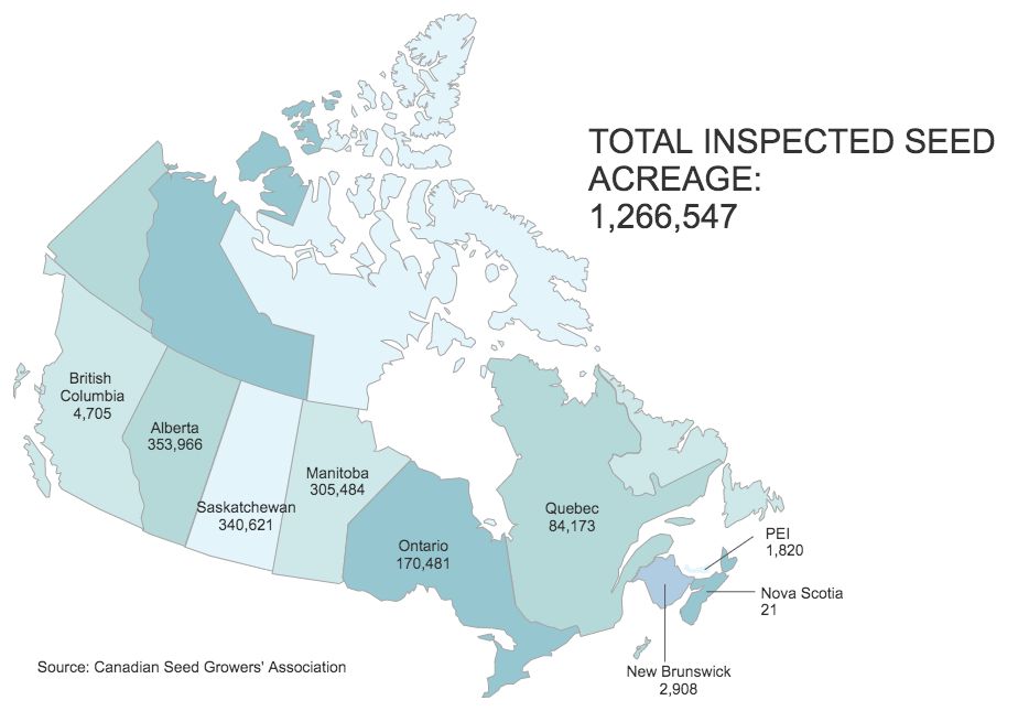
This week, we offer a visual map of inspected seed acres by province.
Alberta remained king in 2020 with 353,966 acres, while Saskatchewan overtook Manitoba with 340,621 acres. That’s a slight change versus 2019, when Manitoba topped Saskatchewan with 341,753 acres compared to Saskatchewan’s 2019 acreage of 330,067.
Manitoba’s seed acres fell by almost 12 per cent in 2020 compared to 2019.
In the East, Nova Scotia’s acreage declined significantly in 2020 (21 inspected acres) over 2019 (51 acres). Also, Prince Edward Island’s acreage fell from 2,983 in 2019 to 1,820 in 2020 — a whopping 39 per cent decrease.
Interestingly, Ontario and Quebec stayed virtually the same. Ontario saw an acreage decrease of less than one per cent while Quebec’s acres grew by just over one per cent.
The country’s total inspected seed acreage declined by 27,340 acres in 2020 compared to 2019, according to the numbers. That’s an improvement over 2019, when acres went down by 41,084 compared to the year prior.
The last time inspected seed acres increased in Canada was 2017, when acres went up 27,166 over the year prior.
Stay tuned as we offer expert insights into some of the reasons for these changes.


