At Canada’s Outdoor Farm Show, The Climate Corporation, a subsidiary of Monsanto Company — which has just agreed to be purchased by Bayer — introduced Climate FieldView into Eastern Canada for the 2017 growing season._x000D_
_x000D_
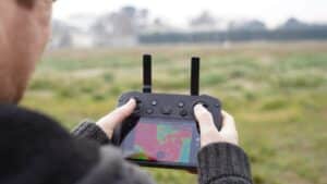
This digital platform can help Canadian farmers easily collect, visualize and analyze their field data in one centralized platform and uncover personalized field insights to support the decisions they make each season to maximize crop productivity._x000D_
_x000D_
“Similar to the launch of biotechnology in the 1990s, we are now experiencing the next revolution of global agriculture through transformative digital technologies that are helping farmers gain a much deeper understanding of their fields, optimize their resources and maximize their return on every acre,” said Mike Stern, The Climate Corporation CEO. “Through the advanced digital tools in the Climate FieldView platform, Canadian farmers can instantly visualize and analyze crop performance with field data maps and satellite imagery, so they can tailor their agronomic practices for the best outcome at the end of the season.”_x000D_
The Climate FieldView platform will be available for purchase in Eastern Canada in winter 2016, so that farmers can begin using it on their farms in time for the 2017 growing season._x000D_
_x000D_
Fundamental to Climate’s data privacy policy is the company’s commitment to respect that farmers own their data, including the data they generate on their farming equipment._x000D_
_x000D_
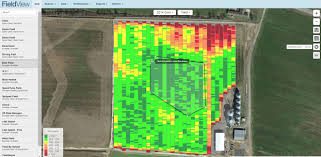
The Climate FieldView platform combines data science with field science and on-farm data to take the complex, environmental interactions that happen in each unique field and turn them into customized insights farmers can use to make data-driven decisions with confidence. Officially launched in 2015, Climate FieldView is now on more than 92 million acres across the United States, with more than 100,000 U.S. farmers actively engaging in Climate’s digital tools._x000D_
_x000D_
Climate FieldView Features in Eastern Canada_x000D_
_x000D_
Data Connectivity – A device that provides seamless data connectivity by transferring field data from a farmer’s equipment into their Climate FieldView account provides simple data collection, storage and visualization through the Climate FieldView Drive. Launched early this year in the United States, FieldView Drive captures key planting data including hybrid and planting population, as well as key harvest data such as yield, and digitally displays that data in a farmer’s Climate FieldView account as the farmer passes through the field. This enables the ability for farmers to easily understand hybrid performance by field, and population with side-by-side views of as-planted and yield data._x000D_
_x000D_
FieldView Drive works with many tractors and combines in Eastern Canada. In addition to the FieldView Drive, farmers can connect their field data to their Climate FieldView account through Precision Planting’s 20/20 monitors and John Deere’s Wireless Data Server (WDS) technology._x000D_
_x000D_
Climate FieldView also offers farmers the option of cloud-to-cloud connection with many other agricultural software systems, as well as manual file upload._x000D_
_x000D_
Yield Analysis Tools – The Climate FieldView platform also provides seed performance analysis tools to help farmers evaluate the impact their agronomic decisions have on yield, so they can build the best plan to maximize profitability for the next season. Farmers can analyze seed performance by field and hybrid, and better understand their field variability by quickly and easily comparing digital field maps side-by-side._x000D_
_x000D_
Advanced Satellite Imagery – With frequent and consistent high-quality field satellite imagery, farmers can find out what’s happening beyond the end rows and identify issues early, prioritize scouting, and take action to protect yield. Climate’s proprietary imagery process provides consistent imagery quality and frequency by using high-resolution imagery with vegetative data from multiple images, in addition to advanced cloud identification. Farmers can also drop geo-located scouting pins on field health images and navigate back to those spots for a closer look, or share with agronomic partners._x000D_
_x000D_
Field-Level Weather – With field-level weather information and notifications, farmers can more efficiently prioritize and plan each day. Farmers can view historical, real-time and forecasted weather to decide which fields are workable based on average field precipitation and wind speed.